Feature: Partridge Run Wildlife Management Area
Distance: 12.65 miles
USGS Map Quads: Rensselaerville, Westerlo
Trail Conference Maps: none
General Description
Section 33 of the Long Path mostly follows old ski trails and snowmobile trails through the Partridge Run Wildlife Management Area. The walking is not difficult and there is little elevation gain, just small ups and downs. The exceptions are at the beginning and end of the section, where the Long Path must climb up to the plateau of Partridge Run. The first 0.3 miles and the last 0.2 miles are on paved roads. The single foot-only trail section is at the very eastern part of Partridge Run. Some of the park trails are also accessible by vehicle, but are little used. The trail passes through many reforestation areas, primarily of Norway spruce and red pine. There are also several ponds and lakes along the way. Views are limited, but more numerous when the leaves are down. Because skiers and snowmobilers share the trails in the winter, there are a number of wet areas, particularly in the beginning of the section.
Access
Take the New York State Thruway to Exit 22 in Selkirk. Turn right on NY Route 144 and go south to NY Route 396. Turn right on Route 396 and follow it 6 miles to South Bethlehem, where Route 396 ends. The road becomes Albany County Route 301 here. Follow Route 301 west another 6 miles to its terminus at NY Route 443 in Clarksville. Turn left on Route 443 and follow it 11 miles to the village of Berne. Continue on Route 443 another 3 miles to West Berne. In West Berne, turn left on Albany County Route 9. Follow Route 9 for about a mile until it makes a sharp left. Continue straight ahead on Bradt Hollow Road. Follow Bradt Hollow Road for about 3 miles, where it intersects Lawton Hollow Road. Turn right on Lawton Hollow Road and follow it for 1.55 miles to the intersection of of Canady Hill Road.
Parking
0.30 East shoulder of Canady Hill Road. (Unlocated)
2.30 Off Bradt Hollow Road. (42.58265°, -74.20622°)
6.35 Tubbs Pond. (42.56730°, -74.18128°)
7.10 Fawn Lake. (42.56185°, -74.16544°)
8.10 Partridge Run Road and Ravine Road (Albany County Route 6). (42.56118°, -74.15094°)
8.60 End of Partridge Run Road. (Unlocated)
9.70 Shale Forest Road. (Unlocated)
12.65 Switz Kill Road and Gifford Hollow Road. (42.57715°, -74.11854°)
Camping
Camping is allowed in Partridge Run, but only in the reforestation areas, not in the Wildlife Management Areas, and 150 feet away from the trail or water source. There is a new lean-to 150 yards straight ahead at the right turn to reach Gifford Hollow Road (11.45 mi).
Trail Description
The trail has been relocated and no longer follows the road in Albany County. Section 33 now starts on Canady Hill Road at the intersection with Lawton Hollow Road In .30 of a mile the trail turns left into the woods. Follow the aqua blazes which will lead you into the Patridge Run Wildlife Management Area. The beginning of this section is on private land and closed during hunting season. Please respect the landowners request.
0.00 From the intersection of Lawton Hollow Road continue south on Canady Hill Road.
0.30 The Long Path turns left and enters the woods on private land. The trail follows a stone wall for a ways. (The trail turns into the woods before reaching Bassler Road)
0.50 The trail leaves the woods road, crosses a small drainage and then starts uphill through the woods.
0.85 Near the top of the hill the trail intersects a snowmobile trail and follows it for a short distance. The trail leaves the snowmobile trail and starts downhill.
1.40 The trail crosses a small drainage, turns left on an old road for a short distance, then turns right heading uphill.
2.10 The trail reaches the top of the hill and turns right.
2.30 The Long Path enters the Partridge Run Game Management Area, the boundary is marked with yellow paint. The trail turns comtinues straight on the Nordic ski trail, continuing straight ahead bordering an area that was clear-cut several years ago. Reach an intersecting trail and bear right. In a short distance another ski trail connects from the right. The LP leaves the ski trail on the left through a brushy area and into fairly open woods following stone walls and logging roads. The trail emerges back on the ski trail at the iron gate on High Point Road.
3.05 The trail crosses High Point Road, and then re-enters the forest following another Nordic ski trail. Shortly, the trail enters a 2010 clear-cut, swings east into a second reforestation area and then back south again. The LP avoids a wet area by leaving the ski trail to the left. Cross an old stone wall to re-join the ski trail to continue.
3.55 The trail reaches a fork. The left fork heads uphill in the woods, while the Long Path continues to the right, following level ground. There is a beaver pond on the right in the distance. Shortly, the trail turns right, crosses the outlet of the beaver pond and enters a hemlock grove. The trail parallels the beaver pond through the hemlocks and then turns left, away from the beaver pond. The trail leaves the hemlocks and enters another spruce grove.
3.95 The trail leaves the spruce forest, crosses an open field, and then turns left on a gravel road that is marked jointly for snowmobilers and skiers. Pass a 2016 clear-cut to the right of the trail, then head generally downhill to the remnants of an old beaver pond, then heads uphill again.
4.20 The trail turns right on a snowmobile trail, continuing south along a stone wall and pass through another 2016 clear-cut area.
4.40 Intersect another snowmobile trail, turn left and follow the trail to Bradt Hollow Road.
4.50 Just before reaching the road, the LP turns right to stay off the road and descends slightly to a zig-zag crossing of the road to continue on a DEC access road.
4.60 Turn right on a snowmobile trail. The trail parallels Bradt Hollow Road for about a quarter of a mile, and then swings away toward the east, passing through a pine forest.
5.35 A snowmobile trail comes in from the right. The Long Path continues straight ahead. The LP avoids another wet area by skirting to higher ground to the right for a short distance and re-joins the ski trail again.
5.85 The trail turns left on gravel Beaver Road.
6.05 Turn right and follow a snowmobile trail downhill through a mature stand of spruce and pine.
6.35 Reach Tubbs Pond, turn right, cross the outlet of the pond to the right on a new foot bridge, and reach the Tubbs Pond parking area. The trail follows the cinder Tubbs Pond access road.

33.1 Tubbs Pond. 2001 [ED WALSH]
6.75 Intersect Fawn Lake Road, turn right and follow it as it parallels Fawn Lake on the right.
7.10 Reach the end of the road and Fawn Lake parking. The trail turns left on a woods road and descends along a gorge following Fawn Lake’s outlet stream. To the left are the remnants of a 1930s deer management area.
7.55 Reach a trail intersection. The trail to the left leads to White Birch Pond. The Long Path turns right, crosses a stream on a bridge, and heads east toward White Birch Pond Road.
7.80 Reach White Birch Pond Road and turn right.
8.00 The trail jogs left on Ravine Road (Albany County Route 6), then right on Partridge Run Road. There is room to park several cars.
8.30 A path leads right about 100 feet to a waterfall along the stream.
8.55 Partridge Run Road bears right and crosses the stream. The Long Path bears left away from the stream, reaches a parking and picnic area at the end of the road, then continues straight ahead through a gate on a gravel road. The trail passes a small pond on the right.
8.95 Intersect a snowmobile trail that goes left. Continue right on the gravel road, intersecting another trail in 500 feet. The trail left leads to Wood Duck Pond. The Long Path bears right.
9.35 Reach a shale road (Kingfisher Road), and turn right.
9.70 Turn left, reach a parking area and continue on a snowmobile trail.
9.90 Reach the crest of the hill and turn right to descend. There are views of the Blackhead Range here when the leaves are down. The trail swings left to reach the eastern escarpment, then left again to follow it.
10.25 Following Partridge Run’s eastern escarpment north, there is a view across Gifford Hollow to Cole Hill.
10.55 The trail bears left, switchbacks uphill beneath a rock ledge, then continues north on the escarpment.
10.80 Reach an old woods road and turn right.
11.10 The trail turns right on another woods road and descends down to a level area before climbing again.
11.30 Reach the bottom of the hill, turn right and enter a hemlock grove, gently climbing again.
11.45 Turn left on another faint woods road, leave Partridge Run and begin descending to the Switz Kill. The trail enters private property.
11.60 The trail turns right and descends through the woods. It emerges on an overgrown field and continues east, following a hedgerow. Watch for the blazes to be sure you are in the correct field. At the end of the first field, cross a stream in a hedgerow and follow the hedgerow across a second field.
12.25 The trail almost reaches the east edge of the field and turns right onto a field drive to reach Gifford Hollow Road. Straight ahead at the turn, about 150 yards, is a new lean-to built by Adam Forti from Boy Scout Troop 79 as an eagle scout project in 2011-2012. The fire place at the lean to was built by Eagle Scout Joe Staubach from Troop 79. The campsite is maintained by Troop 79 and the landowner.
12.45 Reach Gifford Hollow Road and turn left.
12.65 Gifford Hollow Road intersects Switz Kill Road (Albany County Route 1), where this section ends. Turn right on Switz Kill Road to continue.
The Long Path is closed through the private land during hunting season, Continue from the Albany County line as described below.
0.00 Turn left on Lawton Hollow Road and follow it to the Albany County line.
1.05 There is a shale bank on the left, with room to park a couple of cars. This is the Albany county line. The trail heads east on Lawton Hollow Road.
1.55 The trail turns right on gravel Bradt Hollow Road and turns uphill. After about half a mile, the trail passes the Partridge Run boundary.
2.25 The Long Path turns right and enters Partridge Run Wildlife Management Area. There is room to park several cars here, but the parking area is accessible only during dry season. Just past the parking area, the Long Path follows a snowmobile trail over a knoll. The trail then descends into the woods following Partridge Run’s northern boundary. Continue left and follow the description from mile 2.30 above.
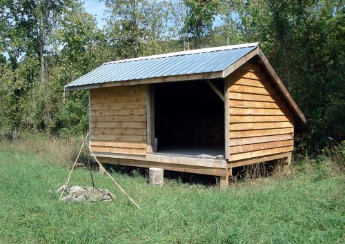
33.2 Lean-to at mile 11.45. 2012 [MARK TRAVER]
Comment: Please be relevant, civil, non-commercial.
More information and photos about this section
DEC has a nice pair of maps of this section
- the right side of the trail from mile 3.15 to 3.4,
- either side of the trail from 3.4 to where Bradt Hollow Road and the snowmobile turn east, at about 4.05,
- the left side of the trail to about 4.55,
- and the right side of the trail to Beaver Road at 5.05.
After mile 5.05, it's all wildlife management area, without lawful camping opportunities until the Gifford Hollow lean-to.Flooding
About 1/4-1/2 mile west of the Beaver Road intersection (around miles 4.6-4.8 in the table), some beaver activity has the snowmobile trail ankle-deep in water. This was not caused by the recent rains - there are tadpoles, newts and fingerling trout living in there, demonstrating that it should e considered a permanent condition - at least until the beavers abandon their project.
A workaround for hikers who don't fancy wading (I waded through there on a day trip yesterday, but returned the way I suggest) is to cross from the snowmobile trail onto Bradt Hollow Road at about mile 4.05, just before it veers east and leaves the road for good. 0.2 miles from jumping off, Cook Hill Road enters from the west, and there is a parking area with a kiosk and a superb view of the valley of Little Schoharie Creek: https://www.flickr.com/photos/ke9tv/34722425073
At 1.0 mile, the view ahead along the road perfectly frames distant Mount Greylock in Massachusetts. Turn left on Beaver Road at 1.05 mile, where the Dancing Dreams riding stable is visible on the far corner on the left. At 1.4 mile into the detour, the hiker will begin to see Long Path blazes on Beaver Road. At 1.6 mile, the Long Path turns right on NYS Snowmobile Corridor 7B at a gate to a woods road, and the directions above can resume from milepost 5.25.
Be aware that the right-hand (east) side of the detour from 1.05 and 1.4 miles is private land, and respect the landowners' rights. Camping is allowed (at least 150 feet from the road) on either side of the road between 0.7 and 1.0 miles in the state reforestation area. It is not permitted in the wildlife management area.
The detour adds only about 0.4 mile to the total. It's considerably more pleasant than the snowmobile trail, because it offers several good views and considerably fewer biting insects. Bradt Hollow Road, Cook Hill Road and Beaver Road are all compacted-surface roads of cinder, shale and sand, and see very little traffic. Ample parking is available 0.2 mile into the detour.
Southbound, the directions are to continue south on Beaver Road when the Long Path and Snowmobile Corridor 7B turn left at the gate south of Wood Pond. Continue 0.35 mile to the end of Beaver Road, and turn left on Bradt Hollow Road. Continue on Bradt Hollow Road for about 0.85 miles, where Cook Hill Road continues straight and Bradt Hollow Road turns right. Turn right and continue on Bradt Hollow Road for another quarter-mile or so, until you start seeing a snowmobile trail in the woods to the right parallel to the road. Cross onto the snowmobile trail and continue to where it crosses Bradt Hollow Road and pick up the guidebook directions from milepost 3.8.
GM's Day 33 of Long Path