14. Sam's Point to Berme Road (Port Ben)
Features: Shawangunk Mountains, Verkeerder Kill Falls
Distance: 11.55 miles
USGS Map Quads: Napanoch, Kerhonkson
Trail Conference Maps: Trail Map 104 (Shawangunk Trails)
General Description
The Long Path enters the northern Shawangunks near Lake Maratanza in Sam's Point Preserve, which is part of Minnewaska State Park Preserve. The northern Shawangunks are one of New York's most popular scenic destinations. Capped by a hard, white conglomerate, the Shawangunks form a long mountain ridge with gently dipping slopes along the surface of the conglomerate, that give way suddenly to great white cliffs. A favored spot for rock climbers from all over the northeastern US, the cliffs provide wonderful views of forested and farmed land in the valley below. In addition, the many miles of carriageways provide unparalleled mountain biking and cross-country skiing opportunities. The trail passes by one of the Shawangunk's finest waterfalls: Verkeerder Kill Falls. The trail follows the Verkeerder Kill Falls Trail (LP Aqua), High Point Trail (red) and Berrypicker Trail (blue), all with numerous views, on its way north to the Mine Hole Trail and spectacular views of the Catskills.
Access
Take the New York State Thruway to Exit 17, Newburgh. Continue west on Interstate Route 84 to Exit 5. Follow NY Route 208 north to NY Route 52. Turn left onto Route 52 and follow it west to the top of the ridge at Cragsmoor. Turn right on Cragsmoor Road and follow it 1.3 miles to the middle of the Hamlet of Cragsmoor. At a three-way intersection, bear right and again make a right onto Sam's Point Road. Follow Sam's Point Road one mile to parking lot at end.
Parking
0.00 Sam's Point Preserve entrance (fee charged). (41.67003°, -74.36162°)
11.55 There are plans for a small parking lot along Berme Road but until that has been built there is only room for one or two cars along the road. More parking is available along Foordemoor Road at the bottom of the Mine Hole Trail (41.75966°, -74.32420°) and along the Rondout Creek (41.76285°, -74.33401°), both about one mile away.
Camping
There is no camping allowed in this section, but at mile 8.05 it is only 0.6 miles west to DEC land - Witch's Hole - where camping is allowed.
Trail Description
0.00 The Long Path turns left near the Sam's Point visitor center parking lot and follows the road that loops around Lake Maratanza. (From the parking lot, turn right on the loop road.)
0.50 The Long Path passes under the cliffs of Sam's Point on the left and comes to a spectacular view to the right. From here you can see south along the ridge to High Point, New Jersey. You can also see across the Wallkill Valley to the Hudson Highlands to the south and east. After the view, the trail turns left and ascends along the road to the top of the cliffs.
0.60 To the left is a road that leads a short distance to Sam's Point. It is worth the detour as the view is even better than along the road. Here you are high enough to see above the high point of Cragsmoor and can see west as well as south and east. Just to the west of the ridge and ten miles south is Basha Kill Wildlife Management Area. On a clear day, you can see all the way into New Jersey and Pennsylvania. The Long Path continues straight ahead on the road, passing through a dense pitch pine forest.
1.05 Reach the intersection with the road that leads down to the former commercial ice caves. About one-quarter mile straight ahead is Lake Maratanza. The Long Path turns right and follows the road to the ice caves a short distance.
1.10 The Long Path turns left and leaves the road. (A side trip to explore the ice caves and return to this junction takes less than an hour and is well worth the time.) The trail ascends through the blueberry bushes for a short distance and then descends gradually through a mixed blueberry-pitch pine forest.
1.25 The trail gradually turns left and goes through an open area covered with blueberry bushes. There are continuous views north towards Mud Pond and Minnewaska State Park with Gertrude's Nose and Castle Point prominent on the skyline.
1.45 The trail enters a denser forest of pitch pine and blueberry.
1.65 The trail enters a hardwood forest with a stream running through the middle. Here a highly unusual stand of birch is found in the middle of the pitch pine and blueberry woods.
1.75 The trail exits the hardwood forest and reemerges in the pitch pine and blueberry scrub. Again there are views towards Minnewaska State Park.
2.00 The Long Path intersects the old trail that once ran from Lake Maratanza to Verkeerder Kill Falls. The trail left to Lake Maratanza is now closed. The Long Path turns right and follows the other branch of the old trail as it descends towards the falls. The forest gradually changes from one of pitch pine and blueberry to a hardwood forest.
2.60 The trail enters a hemlock forest on private property.
2.85 The trail crosses Verkeerder Kill. There are several channels and the crossing may be difficult in times of high water.
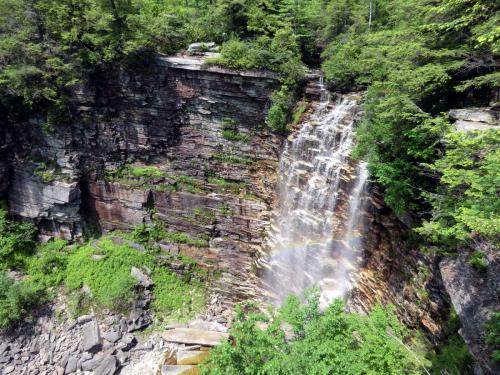
14.1 Verkeerder Kill Falls. 2011 [JAKOB FRANKE]
2.90 The trail reaches an intersection. To the right, a path leads in one hundred feet to a spectacular overlook above Verkeerder Kill Falls. Be careful here, as a misstep will send you plunging to the base of the falls 100 feet below. Please do not proceed past the overlook as the landowner has closed the trail beyond this point. The falls and the overlook are on private property. The landowner has graciously allowed us access to the falls, so please respect his rights and keep the area as you found it. The Long Path turns left back at the intersection and begins to climb to the top of another ridge. The climb is gradual at first, then steep.
3.10 The climb becomes gentler as it gains the ridge crest. After a viewpoint to the left on a conglomerate shelf, the trail turns away from the edge and passes through an area covered with blueberry bushes and small trees.
3.20 The Long Path reaches open slab. There is an intersection with the High Point Trail (red) and the Scenic Trail (lavender). The Scenic Trail, co-blazed with blue SRT markers, follows the previous Long Path route to Mud Pond, 0.6 miles away. The Long Path turns left on the High Point Trail, which is co-blazed with aqua LP disks.
3.55 The trail reaches the first of several fine view points as it continues north along the rim of a ravine, passing alternatingly over slab rock and through blueberry and pine pitch scrub.
4.40 The trail crosses the first of several small seasonal streams as it continues along the rim of the bowl.
5.15 An unmarked trail (Cut-off Trail) on the left leads to the High Point Carriage Road.
5.35 The trail reaches High Point which affords a panoramic view of the Catskills, Mohonk, Minnewaska, and the Hudson Highlands, with the southern Shawangunks hidden behind Sam's Point.
5.70 The trail reaches the Berrypicker Trail (blue), which is co-blazed with LP disks. The red-blazed High Point Trail turns left and descends to reach the High Point Carriage Road in about a tenth of a mile. The Berrypicker Trail and Long Path continue straight ahead for about 150 feet to a fantastic view point overlooking the Rondout Valley and all of the Catskills north of there. This was the site of a fire tower of which the anchors are still visible. The Berrypicker Trail and Long Path turn right at the view point. This section passes through typical pine barren forest, over slab rock, and along many fine view points.
5.95 Great view of Minnewaska and Mohonk.
6.45 A spectacular panoramic view of the Shawangunks and the Catskills.
6.80 The trail approaches the rim of a giant bowl. In a while the forest becomes more deciduous.
7.75 Reach the end of the Berrypicker Trail and turn left on Smiley Carriage Road. From here on the trail is marked with 2x4" LP Aqua blazes. A couple of hundred feet to the right are the remnants of 4-Mile Post, one of the old berrypicker settlements.
8.05 Turn right onto the Mine Hole Trail which is an old fire road from Foordemoor Road up the mountain. The trail descends almost 1600 feet over the next 3 miles. (About 0.6 miles wesr on Smiley Road there are DEC lands - Witch's Hole - where camping is allowed.)
8.10 An unmarked trail to the left leads a to a nearby cabin. In the next mile or so the trail crosses lots of slickrock sections where cairns are used to show the way.
8.50 The trail crosses a stream.
8.70 A short side trail on the right (white blazes) leads to Panther Rock, one of the more outstanding view points along this trail.
8.90 Two large cairns mark an unmaintained trail to the left that leads to Jacob's Ladder. The trail continues downward with several views north of the Catskills and crosses several patches of bare rock that can be very slippery when wet. Slowly the size of the trees increases. The old road can be quite steep at times.

14.2 View of the Catskills from the Mine Hole Trail. 2011 [JAKOB FRANKE]
10.70 Cross a seasonal stream.
10.85 The Long Path turns left off the Mine Hole Trail, crosses a wet area, and passes through some nice open woods on its way down. The Mine Hole Trail continues straight ahead as a white-blazed trail and reaches Foordemoor Road in about 0.8 miles.
11.15 The Long Path crosses a small stream, then passes through a dense stand of mountain laurel before reaching open woods again.
11.55 Reach Berme Road, which is the end of this section.